File:Africa-regions.png
Palije saizi ikulu.
Africa-regions.png (360 × 392 pixels, file size: 8 KB, MIME type: image/png)
Mwakudumula
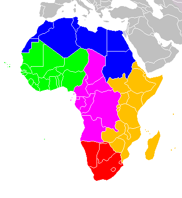
Africa: subregions as delineated by United Nations geographic classification scheme:
Chilolezo
I, the copyright holder of this work, hereby publish it under the following licenses:

|
Chilolezo ntchakupelekeka pakupanga copy, kutandazga panj kusintha na malango gha GNU Free Documentation License, Version 1.2 or any later version published by the Free Software Foundation; with no Invariant Sections, no Front-Cover Texts, and no Back-Cover Texts. A copy of the license is included in the section entitled GNU Free Documentation License. |
| Chinthu ichi ntchakuzomelezgeka na Creative Commons Attribution-Share Alike 3.0 Unported license. | ||
na dango la same or compatible license nga ntchiphya. | ||
| This licensing tag was added to this file as part of the GFDL licensing update. |
This file is licensed under the Creative Commons Attribution-Share Alike 2.5 Generic, 2.0 Generic and 1.0 Generic license.
- Ndimwe ŵakuzomelezgeka:
- kugaŵa – kuti mutandazge, kugaŵa na kusintha ntchito
- kusazga – kusintha chito iyi
- Pa malango ghakulondezga agha:
- Viyambilo vya kuchita – Mukwenela kupeleka malumbo ghawemi, kupeleka linki yakutyonda ku chilolezo, kweneso yowoyaniso pala vinyake vyasintha. Mukwenela kuchita nthena mwakwenelela, kwambula kujikhalila khonde.
- mwa kugaŵana – Pala mwasazga panji mwasintha chinthu, mukwenela kuchitandazga
You may select the license of your choice.

|
File:Africa map regions.svg is a vector version of this file. It should be used in place of this PNG file when not inferior.
File:Africa-regions.png → File:Africa map regions.svg
For more information, see Help:SVG. |
 |
Mbili ya chinthu
Dofyani pa siku/nyengo kuti muone umo vikaonekela pa nyengo iyo.
| Siku/Nyengo | Kachithuzi | Vipimo | Mgwiliski | Ganizo | |
|---|---|---|---|---|---|
| sono | 02:02, 1 Juni 2018 | | 360 × 392 (8 KB) | Vesperius | Reverted to version as of 18:36, 28 May 2018 (UTC) (Most definitions of the regions include the Horn of Africa as part of East Africa, so I'm reverting this back) |
| 18:37, 28 Meyi 2018 |  | 360 × 392 (10 KB) | Vesperius | Reverted to version as of 18:25, 28 May 2018 (UTC) (Messed up, the purple indicating the Horn of Africa didn't show up for me) | |
| 18:36, 28 Meyi 2018 |  | 360 × 392 (8 KB) | Vesperius | Reverted to version as of 01:04, 16 May 2018 (UTC) | |
| 18:25, 28 Meyi 2018 |  | 360 × 392 (10 KB) | Vesperius | Reverted to version as of 18:57, 17 March 2018 (UTC) | |
| 01:04, 16 Meyi 2018 |  | 360 × 392 (8 KB) | Dwo | Reverted to version as of 08:22, 30 August 2015 (UTC) | |
| 18:57, 17 Malichi 2018 |  | 360 × 392 (10 KB) | Maphobbyist | Montenegro border | |
| 08:22, 30 Ogasiti 2015 |  | 360 × 392 (8 KB) | Wiki-Zyron | Reverted to version as of 00:23, 20 December 2012 - Reverted to the last version before someone inexplicably moved Zimbabwe to Southern Africa. Eastern Africa is the correct region - [http://unstats.un.org/unsd/methods/m49/m49regin.htm#africa] | |
| 05:04, 21 Epulelo 2015 |  | 360 × 392 (16 KB) | TAKASUGI Shinji | Corrected the color of Zimbabwe | |
| 15:16, 18 Disembala 2014 |  | 360 × 392 (17 KB) | Hybscher | wrong colors | |
| 22:39, 22 Novembala 2014 |  | 2,000 × 2,050 (342 KB) | Andrew J.Kurbiko | pp |
Magwiliskilo ntchito
Palije majani agho ghogwiliska chinthu ichi.
Umo chinthu chagwiliskikila ntchito
Ma wiki ghanyake agho ghakugwiliska ichi:
- Magwiliskilo pa af.wikipedia.org
- Magwiliskilo pa anp.wikipedia.org
- Magwiliskilo pa ar.wikipedia.org
- Magwiliskilo pa arz.wikipedia.org
- Magwiliskilo pa avk.wikipedia.org
- Magwiliskilo pa azb.wikipedia.org
- Magwiliskilo pa ba.wikipedia.org
- Magwiliskilo pa bg.wikipedia.org
- Magwiliskilo pa blk.wikipedia.org
- Magwiliskilo pa bn.wikipedia.org
- Magwiliskilo pa br.wikipedia.org
- Magwiliskilo pa bxr.wikipedia.org
- Magwiliskilo pa ca.wikipedia.org
- Magwiliskilo pa cy.wikipedia.org
- Magwiliskilo pa de.wikipedia.org
- Magwiliskilo pa el.wikipedia.org
- Magwiliskilo pa en.wikipedia.org
- Southern Africa
- Walvis Bay-Ndola-Lubumbashi Development Road
- N1 road (Gabon)
- User:R4000/Africa(Alt)
- Cairo Road
- User:ArminHammer
- User:Donbert/motherafrica
- User:Donbert/userboxes
- United Nations geoscheme
- United Nations geoscheme for Africa
- Rua Libertadores de África
- Lists of cities in Africa
- Portuguese Africans
- Sam Nujoma Street
- Cairo–Dakar Highway
- N'Djamena–Djibouti Highway
- Portal:Africa/Countries
Wonani magwiliskilo ghanandi ghapa charu gha chinthu ichi.