File:Algeria pipelines map.jpg
Saizi ya chakuona ichi: 624 × 599 pixels. Mu misani inyake: 250 × 240 pixels | 500 × 480 pixels | 832 × 799 pixels.
Chinthu cha kwenekuko (832 × 799 pixels, file size: 203 KB, MIME type: image/jpeg)

|
This economic map image could be re-created using vector graphics as an SVG file. This has several advantages; see Commons:Media for cleanup for more information. If an SVG form of this image is available, please upload it and afterwards replace this template with
{{vector version available|new image name}}.
It is recommended to name the SVG file “Algeria pipelines map.svg”—then the template Vector version available (or Vva) does not need the new image name parameter. |


| Malongosolelo |
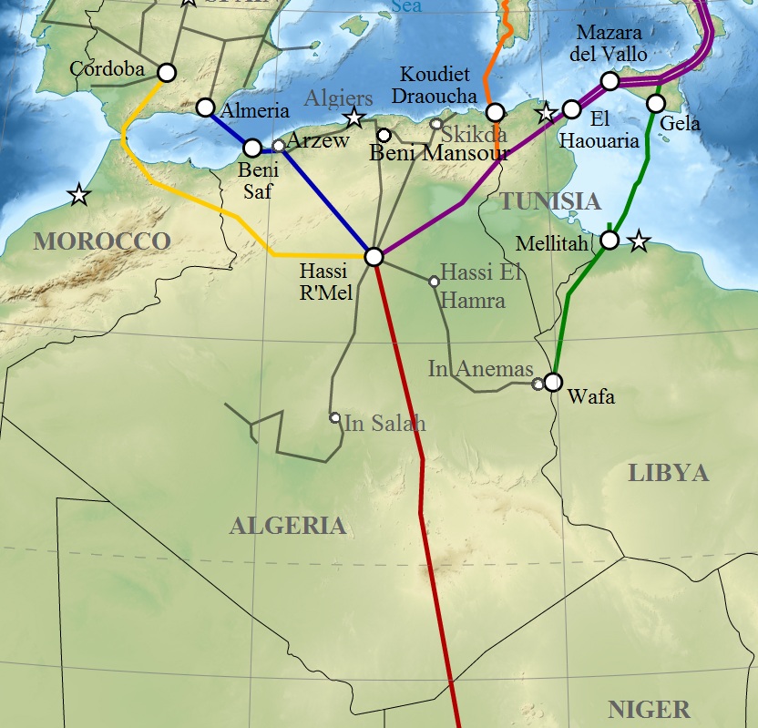
English: Map of gas pipelines across Mediterranee and Sahara : Trans-Saharan, Maghreb–Europe, Medgaz, Galsi, Trans-Mediterranean and Greenstream. Français : Carte des gazoducs traversant le Sahara et la Méditerranée : Trans-saharien, Maghreb–Europe, Gazoduc Medgaz, Galsi, Trans-Méditerranéen et Greenstream. |
| Siku | (UTC) |
| Ukaboni | |
| Mlembi |
|
| This is a retouched picture, which means that it has been digitally altered from its original version. Modifications: Algeria pipelines. The original can be viewed here: Gas pipelines across Mediterranee and Sahara map-en.svg:
|
I, the copyright holder of this work, hereby publish it under the following licenses:
This file is licensed under the Creative Commons Attribution-Share Alike 3.0 Unported, 2.5 Generic, 2.0 Generic and 1.0 Generic license.
- Ndimwe ŵakuzomelezgeka:
- kugaŵa – kuti mutandazge, kugaŵa na kusintha ntchito
- kusazga – kusintha chito iyi
- Pa malango ghakulondezga agha:
- Viyambilo vya kuchita – Mukwenela kupeleka malumbo ghawemi, kupeleka linki yakutyonda ku chilolezo, kweneso yowoyaniso pala vinyake vyasintha. Mukwenela kuchita nthena mwakwenelela, kwambula kujikhalila khonde.
- mwa kugaŵana – Pala mwasazga panji mwasintha chinthu, mukwenela kuchitandazga

|
Chilolezo ntchakupelekeka pakupanga copy, kutandazga panj kusintha na malango gha GNU Free Documentation License, Version 1.2 or any later version published by the Free Software Foundation; with no Invariant Sections, no Front-Cover Texts, and no Back-Cover Texts. A copy of the license is included in the section entitled GNU Free Documentation License. |
You may select the license of your choice.
Original upload log
This image is a derivative work of the following images:
- File:Gas_pipelines_across_Mediterranee_and_Sahara_map-en.svg licensed with Cc-by-sa-3.0,2.5,2.0,1.0, GFDL
- 2009-07-15T14:34:38Z Sémhur 832x1573 (3945956 Bytes) {{Information |Description= {{en|1=Map of gas pipelines across Mediterranee and Sahara : [[:en:Trans-Saharan gas pipeline|Trans-Saharan]], [[:en:Maghreb–Europe Gas Pipeline|Maghreb–Europe]], [[:en:Medgaz|Medgaz]], [[:en:G
Uploaded with derivativeFX
Mbili ya chinthu
Dofyani pa siku/nyengo kuti muone umo vikaonekela pa nyengo iyo.
| Siku/Nyengo | Kachithuzi | Vipimo | Mgwiliski | Ganizo | |
|---|---|---|---|---|---|
| sono | 12:08, 6 Malichi 2011 | | 832 × 799 (203 KB) | Mahmoudb1953 | {{Information |Description={{en|1=Map of gas pipelines across Mediterranee and Sahara : Trans-Saharan, Maghreb–Europe, Medgaz, Galsi, [[:en:Trans-Medit |
Magwiliskilo ntchito
The following page uses this file:
Umo chinthu chagwiliskikila ntchito
Ma wiki ghanyake agho ghakugwiliska ichi:
- Magwiliskilo pa ar.wikipedia.org
- Magwiliskilo pa be-tarask.wikipedia.org
- Magwiliskilo pa be.wikipedia.org
- Magwiliskilo pa bs.wikipedia.org
- Magwiliskilo pa ca.wikipedia.org
- Magwiliskilo pa cy.wikipedia.org
- Magwiliskilo pa de.wikipedia.org
- Magwiliskilo pa el.wikipedia.org
- Magwiliskilo pa en.wikipedia.org
- Magwiliskilo pa eo.wikipedia.org
- Magwiliskilo pa es.wikipedia.org
- Magwiliskilo pa eu.wikipedia.org
- Magwiliskilo pa fr.wikipedia.org
- Magwiliskilo pa hu.wikipedia.org
- Magwiliskilo pa id.wikipedia.org
- Magwiliskilo pa ja.wikipedia.org
- Magwiliskilo pa ka.wikipedia.org
- Magwiliskilo pa lt.wikipedia.org
- Magwiliskilo pa nl.wikipedia.org
- Magwiliskilo pa pt.wikipedia.org
- Magwiliskilo pa ru.wikipedia.org
- Magwiliskilo pa si.wikipedia.org
- Magwiliskilo pa sl.wikipedia.org
- Magwiliskilo pa te.wikipedia.org
- Magwiliskilo pa uk.wikipedia.org
- Magwiliskilo pa uz.wikipedia.org
- Magwiliskilo pa www.wikidata.org
Wonani magwiliskilo ghanandi ghapa charu gha chinthu ichi.