File:Chad sat.jpg

Saizi ya chakuona ichi: 394 × 599 pixels. Mu misani inyake: 158 × 240 pixels | 316 × 480 pixels | 505 × 768 pixels | 1,265 × 1,922 pixels.
Chinthu cha kwenekuko (1,265 × 1,922 pixels, file size: 1.79 MB, MIME type: image/jpeg)
Mwakudumula
| Malongosolelo |
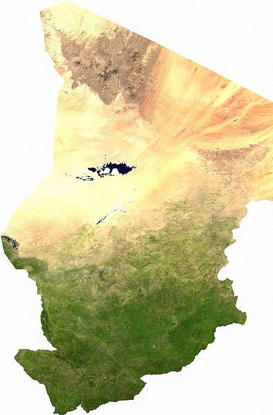
Español: Mapa satelital de Chad, se puede apreciar el contraste entre la zona árida del norte, que corresponde al sur del Sahara; y la zona fértil del sur.
Los musulmanes del norte piden privilegios económicos.
|
| Siku | |
| Ukaboni | user |
| Mlembi | Cwolfsheep |
Chilolezo
| This file is in the public domain, because it was generated by a user, using free sources available at The Map Library.
Note that this does not include the maps in the Global Administrative Areas section of the homepage. |
Mbili ya chinthu
Dofyani pa siku/nyengo kuti muone umo vikaonekela pa nyengo iyo.
| Siku/Nyengo | Kachithuzi | Vipimo | Mgwiliski | Ganizo | |
|---|---|---|---|---|---|
| sono | 03:43, 13 Julayi 2006 | | 1,265 × 1,922 (1.79 MB) | Unquietwiki | ECW to TIFF to JPEG (100% quality; progressive formatting). {{PD-MapLibrary}} |
Magwiliskilo ntchito
The following page uses this file:
Umo chinthu chagwiliskikila ntchito
Ma wiki ghanyake agho ghakugwiliska ichi:
- Magwiliskilo pa af.wikipedia.org
- Magwiliskilo pa als.wikipedia.org
- Magwiliskilo pa ar.wikipedia.org
- Magwiliskilo pa bg.wikipedia.org
- Magwiliskilo pa bs.wikipedia.org
- Magwiliskilo pa ca.wikipedia.org
- Magwiliskilo pa da.wikipedia.org
- Tchad
- Tchads historie
- Wikipedia:Dagens skandinaviske artikel/september 2009
- Wikipedia:Dagens skandinaviske artikel/Svensk/Uge 36, 2009
- Wikipedia:Dagens skandinaviske artikel/august 2012
- Wikipedia:Dagens skandinaviske artikel/Bokmål/Uge 32, 2012
- Wikipedia:Dagens skandinaviske artikel/maj 2014
- Wikipedia:Dagens skandinaviske artikel/Søndag/Uge 20, 2014
- Magwiliskilo pa de.wikipedia.org
- Magwiliskilo pa de.wikiversity.org
- Magwiliskilo pa el.wikipedia.org
- Magwiliskilo pa en.wikipedia.org
- Magwiliskilo pa eo.wikipedia.org
- Magwiliskilo pa es.wikipedia.org
- Magwiliskilo pa eu.wikipedia.org
- Magwiliskilo pa fa.wikipedia.org
- Magwiliskilo pa fr.wikipedia.org
- Magwiliskilo pa hu.wikipedia.org
- Magwiliskilo pa ig.wikipedia.org
- Magwiliskilo pa is.wikipedia.org
- Magwiliskilo pa it.wikipedia.org
- Magwiliskilo pa ja.wikipedia.org
- Magwiliskilo pa ka.wikipedia.org
- Magwiliskilo pa kk.wikipedia.org
- Magwiliskilo pa li.wikipedia.org
- Magwiliskilo pa mn.wikipedia.org
- Magwiliskilo pa mt.wikipedia.org
- Magwiliskilo pa nn.wikipedia.org
- Magwiliskilo pa no.wikipedia.org
Wonani magwiliskilo ghanandi ghapa charu gha chinthu ichi.