File:GNQ orthographic.svg

Size of this PNG preview of this SVG file: 600 × 600 pixels. Mu misani inyake: 240 × 240 pixels | 480 × 480 pixels | 768 × 768 pixels | 1,024 × 1,024 pixels | 2,048 × 2,048 pixels.
Chinthu cha kwenekuko (SVG file, nominally 600 × 600 pixels, file size: 1.21 MB)
Mwakudumula
| Malongosolelo |
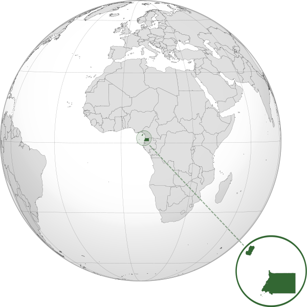
Español: Orthographic map of Equatorial Guinea centered at 1° N, 8° E.
Official territory.
Claimed territories. |
| Siku | |
| Ukaboni |
Chinthu chane with Natural Earth Data This W3C-unspecified vector image was created with Inkscape . |
| Mlembi | Addicted04 |
Chilolezo
I, the copyright holder of this work, hereby publish it under the following license:
Chinthu ichi ntchakuzomelezgeka na Creative Commons Attribution-Share Alike 3.0 Unported license.
- Ndimwe ŵakuzomelezgeka:
- kugaŵa – kuti mutandazge, kugaŵa na kusintha ntchito
- kusazga – kusintha chito iyi
- Pa malango ghakulondezga agha:
- Viyambilo vya kuchita – Mukwenela kupeleka malumbo ghawemi, kupeleka linki yakutyonda ku chilolezo, kweneso yowoyaniso pala vinyake vyasintha. Mukwenela kuchita nthena mwakwenelela, kwambula kujikhalila khonde.
- mwa kugaŵana – Pala mwasazga panji mwasintha chinthu, mukwenela kuchitandazga
Mbili ya chinthu
Dofyani pa siku/nyengo kuti muone umo vikaonekela pa nyengo iyo.
| Siku/Nyengo | Kachithuzi | Vipimo | Mgwiliski | Ganizo | |
|---|---|---|---|---|---|
| sono | 03:01, 8 Julayi 2012 | | 600 × 600 (1.21 MB) | Addicted04 | zoom |
| 00:50, 8 Julayi 2012 |  | 550 × 550 (1.2 MB) | Addicted04 |
Magwiliskilo ntchito
The following page uses this file:
Umo chinthu chagwiliskikila ntchito
Ma wiki ghanyake agho ghakugwiliska ichi:
- Magwiliskilo pa ar.wikipedia.org
- Magwiliskilo pa arz.wikipedia.org
- Magwiliskilo pa ast.wikipedia.org
- Magwiliskilo pa az.wikipedia.org
- Magwiliskilo pa ban.wikipedia.org
- Magwiliskilo pa bg.wikipedia.org
- Magwiliskilo pa bi.wikipedia.org
- Magwiliskilo pa ca.wikipedia.org
- Magwiliskilo pa ce.wikipedia.org
- Magwiliskilo pa cs.wikipedia.org
- Magwiliskilo pa da.wikipedia.org
- Magwiliskilo pa de.wikivoyage.org
- Magwiliskilo pa diq.wikipedia.org
- Magwiliskilo pa el.wikipedia.org
- Magwiliskilo pa en.wikipedia.org
- Magwiliskilo pa es.wikipedia.org
- Magwiliskilo pa eu.wikipedia.org
- Magwiliskilo pa fa.wikipedia.org
- Magwiliskilo pa fi.wikivoyage.org
- Magwiliskilo pa fr.wikinews.org
- Magwiliskilo pa ga.wikipedia.org
- Magwiliskilo pa gl.wikipedia.org
- Magwiliskilo pa gn.wikipedia.org
- Magwiliskilo pa ha.wikipedia.org
- Magwiliskilo pa he.wikipedia.org
- Magwiliskilo pa ht.wikipedia.org
- Magwiliskilo pa hy.wikipedia.org
- Magwiliskilo pa ia.wikipedia.org
- Magwiliskilo pa id.wikipedia.org
- Magwiliskilo pa ie.wikipedia.org
- Magwiliskilo pa incubator.wikimedia.org
- Magwiliskilo pa is.wikipedia.org
- Magwiliskilo pa it.wikipedia.org
- Magwiliskilo pa jam.wikipedia.org
- Magwiliskilo pa ja.wikipedia.org
Wonani magwiliskilo ghanandi ghapa charu gha chinthu ichi.