File:LocationSingapore2.png
Palije saizi ikulu.
LocationSingapore2.png (280 × 148 pixels, file size: 7 KB, MIME type: image/png)

|
This locator map image could be re-created using vector graphics as an SVG file. This has several advantages; see Commons:Media for cleanup for more information. If an SVG form of this image is available, please upload it and afterwards replace this template with
{{vector version available|new image name}}.
It is recommended to name the SVG file “LocationSingapore2.svg”—then the template Vector version available (or Vva) does not need the new image name parameter. |
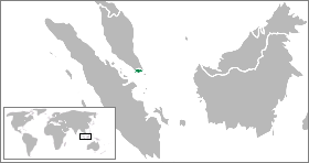
Location map for the Singapore.
Originally created for English Wikipedia by ASDFGHJ.
| |
This work has been released into the public domain by its author, ASDFGHJ, at the English Wikipediya project. This applies worldwide. In case this is not legally possible: |
| Annotations | This image is annotated: View the annotations at Commons |
Mbili ya chinthu
Dofyani pa siku/nyengo kuti muone umo vikaonekela pa nyengo iyo.
| Siku/Nyengo | Kachithuzi | Vipimo | Mgwiliski | Ganizo | |
|---|---|---|---|---|---|
| sono | 07:51, 11 Malichi 2009 | | 280 × 148 (7 KB) | ASDFGHJ | Location map for the Singapore.<br/>Originally created for English Wikipedia by ASDFGHJ. {{PD-user-w|en|English Wikipedia|ASDFGHJ}} {{svg|map}} Category:Locator maps of countries <!--{{ImageUpload|basic}}--> |
Magwiliskilo ntchito
The following page uses this file:
Umo chinthu chagwiliskikila ntchito
Ma wiki ghanyake agho ghakugwiliska ichi:
- Magwiliskilo pa ace.wikipedia.org
- Magwiliskilo pa ar.wikipedia.org
- Magwiliskilo pa awa.wikipedia.org
- Magwiliskilo pa ban.wikipedia.org
- Magwiliskilo pa be.wikipedia.org
- Magwiliskilo pa bn.wikipedia.org
- Magwiliskilo pa ceb.wikipedia.org
- Magwiliskilo pa dv.wikipedia.org
- Magwiliskilo pa en.wikipedia.org
- Magwiliskilo pa fiu-vro.wikipedia.org
- Magwiliskilo pa fr.wikipedia.org
- Magwiliskilo pa gor.wikipedia.org
- Magwiliskilo pa gv.wikipedia.org
- Magwiliskilo pa id.wikipedia.org
- Magwiliskilo pa incubator.wikimedia.org
- Magwiliskilo pa ja.wikipedia.org
- Magwiliskilo pa ka.wikipedia.org
- Magwiliskilo pa mk.wikipedia.org
- Magwiliskilo pa mr.wikipedia.org
- Magwiliskilo pa ms.wikipedia.org
- Magwiliskilo pa new.wikipedia.org
- Magwiliskilo pa pl.wikipedia.org
- Magwiliskilo pa ru.wikipedia.org
- Magwiliskilo pa ru.wikinews.org
- Magwiliskilo pa simple.wiktionary.org
- Magwiliskilo pa tet.wikipedia.org
- Magwiliskilo pa uk.wikipedia.org
- Magwiliskilo pa vi.wikipedia.org
- Magwiliskilo pa yo.wikipedia.org