File:Map of South Africa with Tshwane highlighted (2011).svg

Size of this PNG preview of this SVG file: 684 × 599 pixels. Mu misani inyake: 274 × 240 pixels | 548 × 480 pixels | 876 × 768 pixels | 1,168 × 1,024 pixels | 2,337 × 2,048 pixels | 809 × 709 pixels.
Chinthu cha kwenekuko (SVG file, nominally 809 × 709 pixels, file size: 467 KB)
.svg)
Mwakudumula
| Malongosolelo |
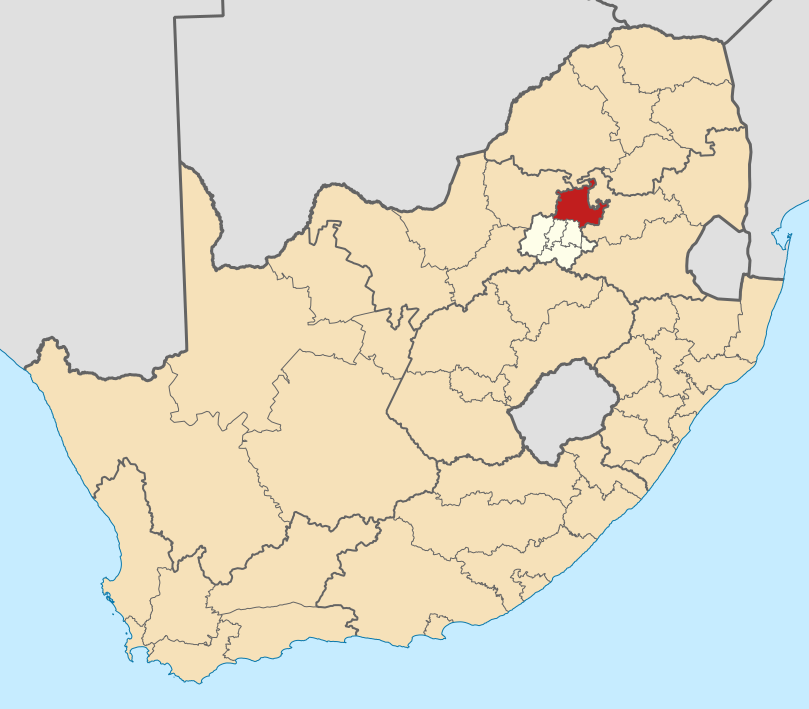
English: Map of district boundaries in South Africa, as they will be after the municipal elections of 18 May 2011, with the City of Tshwane Metropolitan Municipality highlighted in red within Gauteng in yellow. |
| Siku | |
| Ukaboni | Chinthu chane |
| Mlembi | Htonl |
Chilolezo
I, the copyright holder of this work, hereby publish it under the following licenses:

|
Chilolezo ntchakupelekeka pakupanga copy, kutandazga panj kusintha na malango gha GNU Free Documentation License, Version 1.2 or any later version published by the Free Software Foundation; with no Invariant Sections, no Front-Cover Texts, and no Back-Cover Texts. A copy of the license is included in the section entitled GNU Free Documentation License. |
This file is licensed under the Creative Commons Attribution-Share Alike Attribution-Share Alike 4.0 International, 3.0 Unported, 2.5 Generic, 2.0 Generic and 1.0 Generic license.
- Ndimwe ŵakuzomelezgeka:
- kugaŵa – kuti mutandazge, kugaŵa na kusintha ntchito
- kusazga – kusintha chito iyi
- Pa malango ghakulondezga agha:
- Viyambilo vya kuchita – Mukwenela kupeleka malumbo ghawemi, kupeleka linki yakutyonda ku chilolezo, kweneso yowoyaniso pala vinyake vyasintha. Mukwenela kuchita nthena mwakwenelela, kwambula kujikhalila khonde.
- mwa kugaŵana – Pala mwasazga panji mwasintha chinthu, mukwenela kuchitandazga
You may select the license of your choice.
Mbili ya chinthu
Dofyani pa siku/nyengo kuti muone umo vikaonekela pa nyengo iyo.
| Siku/Nyengo | Kachithuzi | Vipimo | Mgwiliski | Ganizo | |
|---|---|---|---|---|---|
| sono | 20:19, 2 Meyi 2011 | | 809 × 709 (467 KB) | Htonl | == Summary == {{Information |Description ={{en|1=Map of district boundaries in South Africa, as they will be after the municipal elections of 18 May 2011, with the [[w:City of Tshwane Metropolitan Municipali |
Magwiliskilo ntchito
The following page uses this file:
Umo chinthu chagwiliskikila ntchito
Ma wiki ghanyake agho ghakugwiliska ichi:
- Magwiliskilo pa af.wikipedia.org
- Pretoria
- Centurion
- Cullinan
- Marabastad
- Brooklyn, Pretoria
- Waterkloof
- Groenkloof
- Hatfield, Pretoria
- Arcadia, Pretoria
- Elarduspark
- Irene
- Bronkhorstspruit
- Valhalla
- Kleinfontein
- Mabopane
- Atteridgeville
- Capital Park
- Hammanskraal
- Rayton
- Die Wilgers
- Winterveld
- Rietfontein, Pretoria
- Highveld
- Erasmuskloof
- Wingate Park
- Pierre van Ryneveldpark
- Moreletapark
- Monument Park
- Waterkloofrif
- Menlopark, Pretoria
- Kloofsig
- Lyttelton
- Constantiapark
- Lynnwood
- Olievenhoutbosch
- Ga-Rankuwa
- Mamelodi
- Soshanguve
- Akasia
- Temba
- Chantelle
- Orchards, Pretoria
- Pretoria-Noord
- Rosslyn
- Laudium
- Lyttelton Manor
- Doringkloof
- Villieria
- Waverley
- Garsfontein
Wonani magwiliskilo ghanandi ghapa charu gha chinthu ichi.
.svg)
.svg)