File:Nigeria Topography.png

Saizi ya chakuona ichi: 662 × 600 pixels. Mu misani inyake: 265 × 240 pixels | 530 × 480 pixels | 848 × 768 pixels | 1,131 × 1,024 pixels | 1,708 × 1,547 pixels.
Chinthu cha kwenekuko (1,708 × 1,547 pixels, file size: 3.03 MB, MIME type: image/png)
zamfa gusau
Mwakudumula
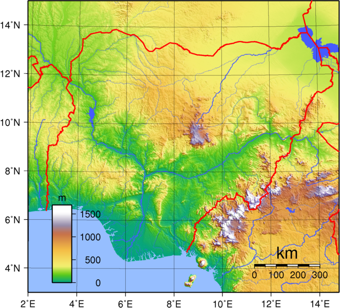
| Malongosolelo | Topographic map of Nigeria. Created with GMT from public domain GLOBE data. |
| Siku | |
| Ukaboni | Chinthu chane |
| Mlembi | Sadalmelik |
Chilolezo
| This work has been released into the public domain by its author, I, Sadalmelik. This applies worldwide. In some countries this may not be legally possible; if so: I, Sadalmelik grants anyone the right to use this work for any purpose, without any conditions, unless such conditions are required by law. |
Mbili ya chinthu
Dofyani pa siku/nyengo kuti muone umo vikaonekela pa nyengo iyo.
| Siku/Nyengo | Kachithuzi | Vipimo | Mgwiliski | Ganizo | |
|---|---|---|---|---|---|
| sono | 20:44, 29 Juni 2007 | | 1,708 × 1,547 (3.03 MB) | Sadalmelik | Better data, better colours |
| 14:32, 22 Juni 2007 |  | 1,708 × 1,547 (2.18 MB) | Sadalmelik | {{Information |Description= |Source=self-made |Date= |Author= Sadalmelik }} | |
| 18:50, 16 Juni 2007 |  | 1,708 × 1,547 (2.1 MB) | Sadalmelik | {{Information |Description=Topographic map of Nigeria. Created with GMT from public domain GLOBE data. |Source=self-made |Date=June 16, 2007 |Author= Sadalmelik }} Category:Maps of Nigeria Category:Topographic maps of Africa |
Magwiliskilo ntchito
The following page uses this file:
Umo chinthu chagwiliskikila ntchito
Ma wiki ghanyake agho ghakugwiliska ichi:
- Magwiliskilo pa af.wikipedia.org
- Magwiliskilo pa als.wikipedia.org
- Magwiliskilo pa an.wikipedia.org
- Magwiliskilo pa ar.wikipedia.org
- Magwiliskilo pa avk.wikipedia.org
- Magwiliskilo pa azb.wikipedia.org
- Magwiliskilo pa bg.wikipedia.org
- Magwiliskilo pa bs.wikipedia.org
- Magwiliskilo pa ca.wikipedia.org
- Magwiliskilo pa ceb.wikipedia.org
- Magwiliskilo pa da.wikipedia.org
- Magwiliskilo pa de.wikipedia.org
- Magwiliskilo pa en.wikipedia.org
- Magwiliskilo pa eo.wikipedia.org
- Magwiliskilo pa fa.wikipedia.org
- Magwiliskilo pa fr.wikipedia.org
- Magwiliskilo pa ha.wikipedia.org
- Magwiliskilo pa hu.wikipedia.org
- Magwiliskilo pa hy.wikipedia.org
- Magwiliskilo pa id.wikipedia.org
- Magwiliskilo pa ig.wikipedia.org
- Magwiliskilo pa ka.wikipedia.org
- Magwiliskilo pa no.wikipedia.org
- Magwiliskilo pa oc.wikipedia.org
- Magwiliskilo pa pt.wikipedia.org
- Magwiliskilo pa ru.wikipedia.org
- Magwiliskilo pa sv.wikipedia.org
- Magwiliskilo pa uk.wikipedia.org
- Magwiliskilo pa vec.wikipedia.org
- Magwiliskilo pa vep.wikipedia.org
- Magwiliskilo pa www.wikidata.org
- Magwiliskilo pa yo.wikipedia.org
- Magwiliskilo pa zh.wikipedia.org