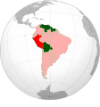
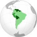
File:Union of South American Nations (orthographic projection).svg

Chinthu cha kwenekuko (SVG file, nominally 551 × 591 pixels, file size: 333 KB)

Chinthu ichi ntchaku Wikimedia Commons ndipo chingagwiliskikaso kunyake. Vakulongosola vake file description page vili pasi apa.

Mwakudumula

Malongosolelo
العربية: اتحاد دول أمريكا الجنوبية
 
أعضاء كاملون
 
أعضاء معلقون
 
أعضاء سابقون
Español: Unión de Naciones Suramericanas (UNASUR)
 
Miembros plenos
 
Miembros suspendidos
 
Antiguos miembros
English: Union of South American Nations (USAN)
 
Current members
 
Suspended members
 
Former members
Português: União de Nações Sul-Americanas (UNASUL)
Nederlands: Unie van Zuid-Amerikaanse Naties (UZAN)
Català: Unió de Nacions Sud-americanes
한국어: 남미 국가 연합
Français : Union des nations sud-américaines (UNASUR)
 
Membres actuels
 
Membres suspendus
 
Anciens membres
Italiano: Unione delle Nazioni Sudamericane
日本語: 南米諸国連合
Nāhuatl: Tlacetilīztli Huitzixachitēcatl Tlācatiyān
中文:南美洲国家联盟
Siku
Ukaboni Chinthu chane
Mlembi Heraldry
Chilolezo
(Kugwiliskaso ntchito ichi)
This image (or parts of it) was created by this user based on Adobe's Photoshop or Inkscape and probably converted to the portable network graphics format. It is (or includes) one of its different original designs, colours or styles from which you can choose.
You are free to share and make derivative works of the file under the conditions that you appropriately attribute it.

বাংলা  English  español  français  italiano  日本語  македонски  sicilianu  中文(简体)  中文(繁體)  +/−

GNU head Chilolezo ntchakupelekeka pakupanga copy, kutandazga panj kusintha na malango gha GNU Free Documentation License, Version 1.2 or any later version published by the Free Software Foundation; with no Invariant Sections, no Front-Cover Texts, and no Back-Cover Texts. A copy of the license is included in the section entitled GNU Free Documentation License.
Other versions
This is a Grey & green orthographic projection map.
العربية: الرجاء، قراءة الميثاق.
বাংলা: দয়া করে, রীতিনীতিটি পড়ুন
Deutsch: Bitte lies die Konventionen.
English: Please, read the conventions.
Español: Por favor, lea las convenciones.
Filipino: Paki-basa ang mga kumbensyon.
Français : S'il vous plaît, lisez les conventions.
हिन्दी: कृपया सभागमों को पढ़ लें.
Bahasa Indonesia: Silakan, baca konvensi.
Italiano: Si prega di leggere le convenzioni.
日本語: 規約をご確認ください。
ქართული: გთხოვთ, გაეცნოთ კონვენციებს.
Português: Por favor, leia as convenções.
Русский: Пожалуйста, прочитайте соглашения.
Українська: Будь ласка, прочитайте конвенції.
Tiếng Việt: Hãy đọc công văn trước khi đăng.
中文(繁體):請檢視常規
中文(简体):请查看常规
World maps

Africa

हिन्दी: अफ्रीका
ქართული: აფრიკა.

Eastern Africa

Southern Africa

Central Africa

Northern Africa

Western Africa

Americas

ქართული: ამერიკა.
हिन्दी: अमेरिका

North America

Central America

Caribbean

South America

Asia

ქართული: აზია.
Português: Ásia.
Українська: Азія.

East

Português: Ásia Oriental.
Українська: Східна Азія.

Central

हिन्दी: मध्य एशिया
Português: Ásia Central.
Українська: Центральна Азія.

Southeast

Bahasa Indonesia: Asia tenggara
Português: Sudeste Asiático.

South

(भारतीय उपमहाद्वीप)
Português: Sul da Ásia.
Українська: Південна Азія.

Western

Português: Sudoeste da Ásia.
Українська: Передня Азія.

Europe

हिन्दी: यूरोप
ქართული: ევროპა.
Português: Europa.
Română: Europa.
Русский: Европа.
Українська: Європа.

Countries

Oceania

हिन्दी: ओशिआनिया
ქართული: ოკეანეთი.
Português: Oceania.
Українська: Океанія.

Intercontinental

Português: Intercontinental.
Українська: Міжконтинентальні.

Historical

English: Unions, Organizations, Kingdoms, Empires
Español: Uniones, Organizaciones, Reinos, Imperios
Filipino: Mga Unyon, Organisasyon, Kaharian, Imperyo
Français : Unions, Organisations, Royaumes, Empires
हिन्दी: संघ, संगठन, राज्य, साम्राज्य व ऐतिहासिक देश
ქართული: გაერთიანებები, ორგანიზაციები, სამეფოები, იმპერიები
Português: Estados extintos.
Tagalog: Mga Unyon, Organisasyon, Kaharian, Imperyo
Українська: Союзи, Організації, Королівства, Імперії
中文(繁體):聯盟、組織、王國和帝國
中文(简体):联盟、组织、王国和帝国

Subnationals

हिन्दी: उपराष्ट्रीय इकाईयाँ

Orthographic projections maps created by Heraldry:

SVG genesis
InfoField
 
The source code of this SVG is invalid due to an error.
 
This W3C-invalid world map was created with Inkscape.
 
SVG watermarked with invisible embedded text.

Chilolezo

I, the copyright holder of this work, hereby publish it under the following license:
GNU head Chilolezo ntchakupelekeka pakupanga copy, kutandazga panj kusintha na malango gha GNU Free Documentation License, Version 1.2 or any later version published by the Free Software Foundation; with no Invariant Sections, no Front-Cover Texts, and no Back-Cover Texts. A copy of the license is included in the section entitled GNU Free Documentation License.
w:en:Creative Commons
Viyambilo vya kuchita mwa kugaŵana
Chinthu ichi ntchakuzomelezgeka na Creative Commons Attribution-Share Alike 3.0 Unported license.
Ndimwe ŵakuzomelezgeka:
  • kugaŵa – kuti mutandazge, kugaŵa na kusintha ntchito
  • kusazga – kusintha chito iyi
Pa malango ghakulondezga agha:
  • Viyambilo vya kuchita – Mukwenela kupeleka malumbo ghawemi, kupeleka linki yakutyonda ku chilolezo, kweneso yowoyaniso pala vinyake vyasintha. Mukwenela kuchita nthena mwakwenelela, kwambula kujikhalila khonde.
  • mwa kugaŵana – Pala mwasazga panji mwasintha chinthu, mukwenela kuchitandazga

na dango la same or compatible license nga ntchiphya.

This licensing tag was added to this file as part of the GFDL licensing update.

Captions

Add a one-line explanation of what this file represents

Items portrayed in this file

depicts English

copyrighted English

inception English

2009

media type English

image/svg+xml

Mbili ya chinthu

Dofyani pa siku/nyengo kuti muone umo vikaonekela pa nyengo iyo.

(viphya chomene | vyakale chomene) Wonani (vyasono 10 | ) (10 | 20 | 50 | 100 | 250 | 500)
Siku/NyengoKachithuziVipimoMgwiliskiGanizo
sono11:01, 27 Juni 2024Kachithuzi kachoko nga mpha 11:01, 27 Juni 2024551 × 591 (333 KB)ChipmunkdavisUpdating Brazil per talkpage request, and simplifying the code by deleting duplicate objects and grouping parts of countries
14:17, 15 Julayi 2023Kachithuzi kachoko nga mpha 14:17, 15 Julayi 2023517 × 554 (426 KB)NoonIcarusReverted to version as of 13:50, 15 July 2023 (UTC) Unexplained revert
14:13, 15 Julayi 2023Kachithuzi kachoko nga mpha 14:13, 15 Julayi 2023550 × 551 (331 KB)YmnesReverted to version as of 08:03, 9 April 2023 (UTC)
13:50, 15 Julayi 2023Kachithuzi kachoko nga mpha 13:50, 15 Julayi 2023517 × 554 (426 KB)NoonIcarusReverted to version as of 17:41, 2 January 2023 (UTC) The colors should be fixed in the wikis in that case, it shouldn't be an obstacle for improvement. I will take this task.
08:03, 9 Epulelo 2023Kachithuzi kachoko nga mpha 08:03, 9 Epulelo 2023550 × 551 (331 KB)YmnesReverted to version as of 16:57, 22 June 2022 (UTC), this map is used on several wiki's but not with your colors
17:41, 2 Janyuwale 2023Kachithuzi kachoko nga mpha 17:41, 2 Janyuwale 2023517 × 554 (426 KB)NoonIcarusUsing red as a more suitable color for former members
16:57, 22 Juni 2022Kachithuzi kachoko nga mpha 16:57, 22 Juni 2022550 × 551 (331 KB)NexusKnotssorry :c it my friend who revert
16:49, 22 Juni 2022Kachithuzi kachoko nga mpha 16:49, 22 Juni 2022550 × 551 (433 KB)NexusKnotsReverted to version as of 04:06, 5 December 2009 (UTC)
00:28, 11 Malichi 2020Kachithuzi kachoko nga mpha 00:28, 11 Malichi 2020550 × 551 (331 KB)AntoFranCorrección del fondo. La esfera estaba movida fuera de la circunferencia.
20:16, 10 Malichi 2020Kachithuzi kachoko nga mpha 20:16, 10 Malichi 2020550 × 551 (521 KB)JuangattiReverted to version as of 20:05, 10 March 2020 (UTC)
(viphya chomene | vyakale chomene) Wonani (vyasono 10 | ) (10 | 20 | 50 | 100 | 250 | 500)

Palije majani agho ghogwiliska chinthu ichi.

Umo chinthu chagwiliskikila ntchito

Ma wiki ghanyake agho ghakugwiliska ichi:

Wonani magwiliskilo ghanandi ghapa charu gha chinthu ichi.

Metadata