File:Vegetation.png

Saizi ya chakuona ichi: 800 × 359 pixels. Mu misani inyake: 320 × 144 pixels | 640 × 287 pixels | 1,385 × 622 pixels.
Chinthu cha kwenekuko (1,385 × 622 pixels, file size: 85 KB, MIME type: image/png)
Mwakudumula
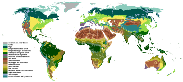
| Malongosolelo | The main biomes in the world. Drawn by hand using maps. |
| Siku | |
| Ukaboni |
The blank world map in Commons and WSOY Iso karttakirja for the information. Referred to over a hundred sources, but here are some of the more extensively used ones: [1], [2], [3], [4], [5], [6], [7], [8], [9], [10] |
| Mlembi | Ville Koistinen (user Vzb83) |
| Other versions |
Derivative works of this file: |
![[5]](https://www.surfaceview.co.uk/storage/image/VMA0018.jpg)
![[6]](https://upload.wikimedia.org/wikipedia/commons/4/4f/Vegetationszonen.png)
![[7]](https://esdac.jrc.ec.europa.eu/images/Eudasm/Africa/images/maps/download/afr_veg.jpg)
![[8]](https://www.researchgate.net/profile/Julie-Morin-9/publication/319979374/figure/fig2/AS:614404802478081@1523496928789/UNESCO-AETFAT-UNSO-Whites-vegetation-map-of-Africa-The-Guineo-Congolian-regional.png)
![[9]](https://www.researchgate.net/profile/Andrea-Kay/publication/276452894/figure/fig1/AS:623557285523457@1525679050775/Map-of-study-area-showing-modern-potential-natural-vegetation-simplified-from-White.png)
![[10]](https://i.pinimg.com/originals/5d/b3/b5/5db3b5b71e47b5467d8df815cd525df5.png)

|
This biogeographical map image could be re-created using vector graphics as an SVG file. This has several advantages; see Commons:Media for cleanup for more information. If an SVG form of this image is available, please upload it and afterwards replace this template with
{{vector version available|new image name}}.
It is recommended to name the SVG file “Vegetation.svg”—then the template Vector version available (or Vva) does not need the new image name parameter. |
Chilolezo
I, the copyright holder of this work, hereby publish it under the following licenses:

|
Chilolezo ntchakupelekeka pakupanga copy, kutandazga panj kusintha na malango gha GNU Free Documentation License, Version 1.2 or any later version published by the Free Software Foundation; with no Invariant Sections, no Front-Cover Texts, and no Back-Cover Texts. A copy of the license is included in the section entitled GNU Free Documentation License. |
| Chinthu ichi ntchakuzomelezgeka na Creative Commons Attribution-Share Alike 3.0 Unported license. | ||
na dango la same or compatible license nga ntchiphya. | ||
| This licensing tag was added to this file as part of the GFDL licensing update. |
This file is licensed under the Creative Commons Attribution-Share Alike 2.5 Generic, 2.0 Generic and 1.0 Generic license.
- Ndimwe ŵakuzomelezgeka:
- kugaŵa – kuti mutandazge, kugaŵa na kusintha ntchito
- kusazga – kusintha chito iyi
- Pa malango ghakulondezga agha:
- Viyambilo vya kuchita – Mukwenela kupeleka malumbo ghawemi, kupeleka linki yakutyonda ku chilolezo, kweneso yowoyaniso pala vinyake vyasintha. Mukwenela kuchita nthena mwakwenelela, kwambula kujikhalila khonde.
- mwa kugaŵana – Pala mwasazga panji mwasintha chinthu, mukwenela kuchitandazga
You may select the license of your choice.
Mbili ya chinthu
Dofyani pa siku/nyengo kuti muone umo vikaonekela pa nyengo iyo.
| Siku/Nyengo | Kachithuzi | Vipimo | Mgwiliski | Ganizo | |
|---|---|---|---|---|---|
| sono | 18:55, 24 Malichi 2024 | | 1,385 × 622 (85 KB) | Berkserker | Added more level of detail, particularly to montane and arid regions. Corrections to savannas. |
| 21:44, 18 Sekutembala 2023 |  | 1,385 × 622 (81 KB) | Berkserker | Minor correction to key | |
| 21:01, 18 Sekutembala 2023 |  | 1,385 × 622 (80 KB) | Berkserker | Slight correction to Eastern Australia | |
| 09:37, 11 Ogasiti 2020 |  | 1,385 × 622 (80 KB) | Berkserker | Corrections to Madagascar | |
| 18:35, 6 Ogasiti 2020 |  | 1,385 × 622 (80 KB) | Berkserker | Minor optimization according to Dyer 2006 | |
| 07:01, 5 Ogasiti 2020 |  | 1,385 × 622 (80 KB) | Berkserker | Added a third source: Dyer 2006, specifically to address the issues in Eastern USA | |
| 03:40, 15 Juni 2020 |  | 1,385 × 622 (80 KB) | Berkserker | More corrections as well as fixing remaining dead pixels | |
| 13:22, 9 Juni 2020 |  | 1,385 × 622 (80 KB) | Berkserker | Further corrections based on the same sources | |
| 07:20, 21 Malichi 2020 |  | 1,385 × 622 (80 KB) | Berkserker | Minor correction to Andean montane forests | |
| 07:09, 21 Malichi 2020 |  | 1,385 × 622 (80 KB) | Berkserker | Fixed key and map colors not matching |
Magwiliskilo ntchito
Palije majani agho ghogwiliska chinthu ichi.
Umo chinthu chagwiliskikila ntchito
Ma wiki ghanyake agho ghakugwiliska ichi:
- Magwiliskilo pa bh.wikipedia.org
- Magwiliskilo pa bn.wikipedia.org
- Magwiliskilo pa bs.wikipedia.org
- Magwiliskilo pa ckb.wikipedia.org
- Magwiliskilo pa cs.wikipedia.org
- Magwiliskilo pa el.wikipedia.org
- Magwiliskilo pa en.wikipedia.org
- Magwiliskilo pa en.wikibooks.org
- Magwiliskilo pa et.wikipedia.org
- Magwiliskilo pa eu.wikipedia.org
- Magwiliskilo pa fa.wikipedia.org
- Magwiliskilo pa fr.wikipedia.org
- Magwiliskilo pa hi.wikibooks.org
- Magwiliskilo pa ik.wikipedia.org
- Magwiliskilo pa ku.wikipedia.org
- Magwiliskilo pa mk.wikipedia.org
- Magwiliskilo pa mt.wikipedia.org
- Magwiliskilo pa no.wikipedia.org
- Magwiliskilo pa oc.wikipedia.org
- Magwiliskilo pa om.wikipedia.org
- Magwiliskilo pa pnb.wikipedia.org
- Magwiliskilo pa ps.wikipedia.org
- Magwiliskilo pa pt.wikipedia.org
- Magwiliskilo pa si.wikipedia.org
- Magwiliskilo pa ta.wikipedia.org
- Magwiliskilo pa th.wikipedia.org
- Magwiliskilo pa tr.wikipedia.org
- Magwiliskilo pa ur.wikipedia.org
- Magwiliskilo pa vi.wikipedia.org
- Magwiliskilo pa vls.wikipedia.org
- Magwiliskilo pa war.wikipedia.org
- Magwiliskilo pa www.wikidata.org
- Magwiliskilo pa zh-yue.wikipedia.org
- Magwiliskilo pa zh.wikipedia.org