File:Ethiopia shaded relief map 1999, CIA.jpg

Saizi ya chakuona ichi: 498 × 599 pixels. Mu misani inyake: 199 × 240 pixels | 399 × 480 pixels | 1,010 × 1,215 pixels.
Chinthu cha kwenekuko (1,010 × 1,215 pixels, file size: 222 KB, MIME type: image/jpeg)
Mwakudumula
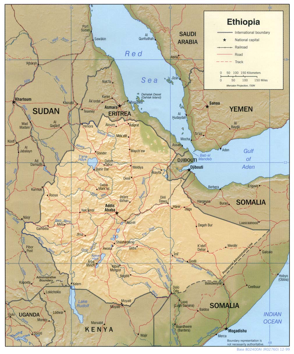
| Malongosolelo | Shaded relief map of Ethiopia, 1999, produced by the U.S. Central Intelligence Agency. |
| Siku | |
| Ukaboni |
University of Texas Libraries, Perry-Castañeda Library Map Collection: Ethiopia Maps |
| Mlembi | CIA |
| Other versions |
Derivative works of this file: |
Chilolezo
| This image is a work of a Central Intelligence Agency employee, taken or made as part of that person's official duties. As a Work of the United States Government, this image or media is in the public domain in the United States.
|

|
Mbili ya chinthu
Dofyani pa siku/nyengo kuti muone umo vikaonekela pa nyengo iyo.
| Siku/Nyengo | Kachithuzi | Vipimo | Mgwiliski | Ganizo | |
|---|---|---|---|---|---|
| sono | 11:23, 22 Febuluwale 2006 | | 1,010 × 1,215 (222 KB) | Lupo | Shaded relief map of Ethiopia. Source: [http://www.lib.utexas.edu/maps/africa/ethiopia_rel99.jpg] from the [http://www.lib.utexas.edu/maps/ethiopia.html Perry-Castañeda Library Map Collection]. {{PD-USGov-CIA}} Category:Maps of Cameroon |
Magwiliskilo ntchito
Palije majani agho ghogwiliska chinthu ichi.
Umo chinthu chagwiliskikila ntchito
Ma wiki ghanyake agho ghakugwiliska ichi:
- Magwiliskilo pa ar.wikipedia.org
- Magwiliskilo pa ast.wikipedia.org
- Magwiliskilo pa av.wikipedia.org
- Magwiliskilo pa ba.wikipedia.org
- Magwiliskilo pa bg.wikipedia.org
- Magwiliskilo pa br.wikipedia.org
- Magwiliskilo pa bs.wikipedia.org
- Magwiliskilo pa ca.wikipedia.org
- Magwiliskilo pa ckb.wikipedia.org
- Magwiliskilo pa cs.wikipedia.org
- Magwiliskilo pa da.wikipedia.org
- Magwiliskilo pa de.wikinews.org
- Magwiliskilo pa el.wikipedia.org
- Magwiliskilo pa en.wikipedia.org
- Magwiliskilo pa fa.wikipedia.org
- Magwiliskilo pa fr.wikipedia.org
- Magwiliskilo pa gcr.wikipedia.org
- Magwiliskilo pa he.wikipedia.org
- Magwiliskilo pa he.wiktionary.org
- Magwiliskilo pa hr.wiktionary.org
- Magwiliskilo pa id.wikipedia.org
- Magwiliskilo pa io.wikipedia.org
- Magwiliskilo pa it.wikipedia.org
- Magwiliskilo pa jv.wikipedia.org
- Magwiliskilo pa ka.wikipedia.org
- Magwiliskilo pa ku.wikipedia.org
- Magwiliskilo pa la.wikipedia.org
- Magwiliskilo pa ml.wikipedia.org
- Magwiliskilo pa mzn.wikipedia.org
- Magwiliskilo pa nl.wikipedia.org
- Magwiliskilo pa no.wikipedia.org
- Magwiliskilo pa os.wikipedia.org
- Magwiliskilo pa pl.wikipedia.org
Wonani magwiliskilo ghanandi ghapa charu gha chinthu ichi.