File:Royaumes ci.jpg
Saizi ya chakuona ichi: 605 × 599 pixels. Mu misani inyake: 242 × 240 pixels | 485 × 480 pixels | 810 × 802 pixels.
Chinthu cha kwenekuko (810 × 802 pixels, file size: 92 KB, MIME type: image/jpeg)

|
This locator map image could be re-created using vector graphics as an SVG file. This has several advantages; see Commons:Media for cleanup for more information. If an SVG form of this image is available, please upload it and afterwards replace this template with
{{vector version available|new image name}}.
It is recommended to name the SVG file “Royaumes ci.svg”—then the template Vector version available (or Vva) does not need the new image name parameter. |


Mwakudumula
| Malongosolelo |
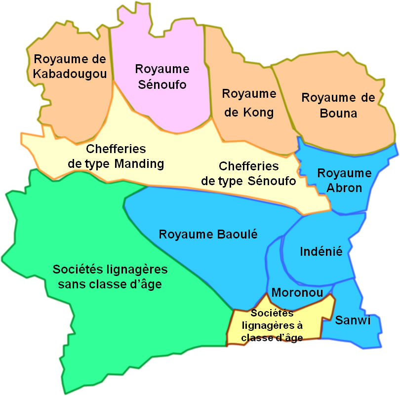
English: Precolonial political situation in Côte d'Ivoire with the different kingdoms, tribal societies with or without age classes. Français : Situation politique précoloniale de la Côte d'Ivoire avec les différents royaumes, les sociétés lignagères sans classe d'âge et les sociétés lignagères à classe d'âge. |
| Ukaboni | Chinthu chane |
| Mlembi | Zenman |
Carte établie à partir des informations de l'ouvrage de Jean Noël Loucou, Côte d’Ivoire : les résistances à la conquête coloniale, Éditions CERAP, Abidjan, 2007, page 16
Chilolezo
I, the copyright holder of this work, hereby publish it under the following licenses:

|
Chilolezo ntchakupelekeka pakupanga copy, kutandazga panj kusintha na malango gha GNU Free Documentation License, Version 1.2 or any later version published by the Free Software Foundation; with no Invariant Sections, no Front-Cover Texts, and no Back-Cover Texts. A copy of the license is included in the section entitled GNU Free Documentation License. |
This file is licensed under the Creative Commons Attribution-Share Alike 3.0 Unported, 2.5 Generic, 2.0 Generic and 1.0 Generic license.
- Ndimwe ŵakuzomelezgeka:
- kugaŵa – kuti mutandazge, kugaŵa na kusintha ntchito
- kusazga – kusintha chito iyi
- Pa malango ghakulondezga agha:
- Viyambilo vya kuchita – Mukwenela kupeleka malumbo ghawemi, kupeleka linki yakutyonda ku chilolezo, kweneso yowoyaniso pala vinyake vyasintha. Mukwenela kuchita nthena mwakwenelela, kwambula kujikhalila khonde.
- mwa kugaŵana – Pala mwasazga panji mwasintha chinthu, mukwenela kuchitandazga
You may select the license of your choice.
| Annotations | This image is annotated: View the annotations at Commons |
Mbili ya chinthu
Dofyani pa siku/nyengo kuti muone umo vikaonekela pa nyengo iyo.
| Siku/Nyengo | Kachithuzi | Vipimo | Mgwiliski | Ganizo | |
|---|---|---|---|---|---|
| sono | 15:29, 12 Disembala 2008 | | 810 × 802 (92 KB) | Zenman | {{Information |Description={{fr|1=Situation politique précoloniale de la Côte d'Ivoire avec les différents royaumes, les sociétés lignagères sans classe d'âge et les sociétés lignagères à classe d'âge.}} |Source=travail personnel (own work) |A |
Magwiliskilo ntchito
The following page uses this file:
Umo chinthu chagwiliskikila ntchito
Ma wiki ghanyake agho ghakugwiliska ichi:
- Magwiliskilo pa af.wikipedia.org
- Magwiliskilo pa ar.wikipedia.org
- Magwiliskilo pa ca.wikipedia.org
- Magwiliskilo pa en.wikipedia.org
- Magwiliskilo pa es.wikipedia.org
- Magwiliskilo pa fa.wikipedia.org
- Magwiliskilo pa fr.wikipedia.org
- Magwiliskilo pa io.wikipedia.org
- Magwiliskilo pa lt.wikipedia.org
- Magwiliskilo pa pt.wikipedia.org
- Magwiliskilo pa sd.wikipedia.org
- Magwiliskilo pa si.wikipedia.org
- Magwiliskilo pa te.wikipedia.org